Toronto is seeing torrential rain as Hurricane Beryl’s remnants move over the city. Here is when it will stop
It could be a messy afternoon commute in Toronto as the remnants of Hurricane Beryl continue to bring torrential rain to the city.
CP24 Meteorologist Bill Coulter says that while the “main shield of precipitation from the storm” moved through the GTA this morning, there is the potential for another heavy band of rain and thunderstorms after 5 p.m.
Coulter says that the rain will then continue off and on throughout the evening before coming to a stop sometime early Thursday morning.
Most of the GTA will see about two weeks’ worth of rain in a day but Coulter said that some areas in the north GTA could see a month’s worth. However the storm will come in gaps, consistent with the breakup of a hurricane.
“So instead of having this perfectly round shape that you saw in the Caribbean, it’s been stretched out. It’s taking on post-tropical characteristics. So it’s got kind of these branches and arms of precipitation,” Coulter said.
Environment Canada said “torrential downpours” are expected in the region as the storm system passes through Wednesday and Thursday. Some areas could see local rainfall amounts of 40 to 60 mm, with rates of 20 to 40 mm/h at times.
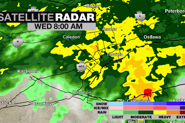 A radar image is seen as the remnants of Hurricane Beryl move into the Toronto area Wednesday July 10, 2024.
Flooding in Toronto
Ponding was reported on a number of busy roads around the city Wednesday morning amid the downpour. Cars could be seen driving through about a foot of water on stretches of Lake Shore Boulevard.
 Cars make their way along a flooded stretch of Lake Shore Boulevard in downtown Toronto amid a heavy downpour Wednesday July 10, 2024.
“Heavy downpours can cause flash floods and water pooling on roads. Localized flooding in low-lying areas is possible,” Environment Canada warned. “If visibility is reduced while driving, slow down, watch for tail lights ahead and be prepared to stop.”
Pearson International Airport was not reporting any significant delays Wednesday morning, but advised travellers that some delays are possible because of the weather.
The Toronto and Region Conservation Authority issued a flood watch because of the heavy rainfall, saying that shorelines, rivers and streams within the GTA “should be considered dangerous as this rainfall will result in higher flows, rapidly changing water levels, and unstable riverbanks.”
People are being advised to exercise, extra caution around bodies of water, especially with children and pets.
Toronto temperatures dip
Berryl’s remnants blew away a hot air mass which had been sitting over the city for several days, ending a heat warning that had been in place for the city.
 Heavy rainfall is expected in Toronto on Wednesday as the remnants of Hurricane Beryl hit Ontario. (Chris Fox/ CP24)
In terms of temperature, a high of 23C is expected in Toronto today.
The rain is expected to last into early Thursday morning before tapering off. Thursday’s expected to be cloudy with a high of 24 C.
Sunshine and higher temperatures are expected to return for the weekend, with a high of 28C on Friday and 29 C Saturday.
View original article here Source

Botanic Hearth Rosemary Hair Oil with Biotin for Hair Care, Strengthening, Nourishing, and Volumizing Formula with…
$20.99 (as of July 26, 2024 14:11 GMT -05:00 - More infoProduct prices and availability are accurate as of the date/time indicated and are subject to change. Any price and availability information displayed on [relevant Amazon Site(s), as applicable] at the time of purchase will apply to the purchase of this product.)
Queen Size 4 Piece Sheet Set - Comfy Breathable & Cooling Sheets - Hotel Luxury Bed Sheets for Women & Men…
$29.99 (as of July 26, 2024 14:11 GMT -05:00 - More infoProduct prices and availability are accurate as of the date/time indicated and are subject to change. Any price and availability information displayed on [relevant Amazon Site(s), as applicable] at the time of purchase will apply to the purchase of this product.)
Jacked Factory Creatine Monohydrate Powder 425g - Creatine Supplement for Increased Muscle Mass*,…
$29.99 (as of July 26, 2024 14:11 GMT -05:00 - More infoProduct prices and availability are accurate as of the date/time indicated and are subject to change. Any price and availability information displayed on [relevant Amazon Site(s), as applicable] at the time of purchase will apply to the purchase of this product.)
Stanley Quencher H2.0 FlowState Stainless Steel Vacuum Insulated Tumbler with Lid and Straw for Water, Iced…
$46.00 (as of July 26, 2024 14:11 GMT -05:00 - More infoProduct prices and availability are accurate as of the date/time indicated and are subject to change. Any price and availability information displayed on [relevant Amazon Site(s), as applicable] at the time of purchase will apply to the purchase of this product.)
Amazon Basics 1/2-Inch Extra Thick Exercise Mat with Carrying Strap
$26.99 (as of July 26, 2024 14:11 GMT -05:00 - More infoProduct prices and availability are accurate as of the date/time indicated and are subject to change. Any price and availability information displayed on [relevant Amazon Site(s), as applicable] at the time of purchase will apply to the purchase of this product.)
Bedsure Satin Pillow Cases 2 Pack Queen - Grey Satin Pillowcase for Hair and Skin - Similar to Silk Pillow Cases…
$10.99 (as of July 26, 2024 14:11 GMT -05:00 - More infoProduct prices and availability are accurate as of the date/time indicated and are subject to change. Any price and availability information displayed on [relevant Amazon Site(s), as applicable] at the time of purchase will apply to the purchase of this product.)
Sunstar 888JC GUM Advanced Care Flossers, Fresh Mint, Vitamin E & Fluoride, 150 Count (packaging may vary)
$5.97 (as of July 26, 2024 14:11 GMT -05:00 - More infoProduct prices and availability are accurate as of the date/time indicated and are subject to change. Any price and availability information displayed on [relevant Amazon Site(s), as applicable] at the time of purchase will apply to the purchase of this product.)
Utopia Bedding Bed Sheet Set - 4 Piece Queen Bedding - Soft Brushed Microfiber Fabric - Shrinkage & Fade Resistant…
$26.99 (as of July 26, 2024 14:11 GMT -05:00 - More infoProduct prices and availability are accurate as of the date/time indicated and are subject to change. Any price and availability information displayed on [relevant Amazon Site(s), as applicable] at the time of purchase will apply to the purchase of this product.)
Pure Protein Bars - Nutritious, Gluten Free protein bar, made with Whey protein blend - low sugar, protein snack.…
$10.47 (as of July 26, 2024 14:11 GMT -05:00 - More infoProduct prices and availability are accurate as of the date/time indicated and are subject to change. Any price and availability information displayed on [relevant Amazon Site(s), as applicable] at the time of purchase will apply to the purchase of this product.)