Low-lying areas of Ottawa River at increased risk of flooding in coming weeks
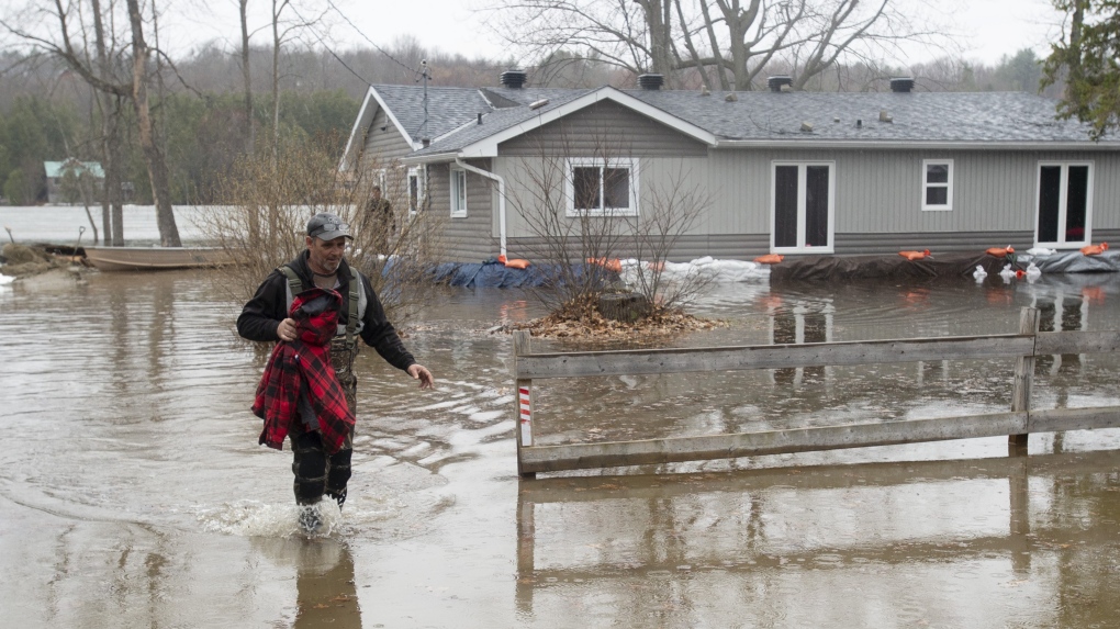
Increasing water levels in the Ottawa River basin could create flooding in low-lying areas in the coming weeks, after above-normal temperatures and a recent spring storm increase the risk across the region.
The Ottawa River Planning Board is warning residents between Mattawa to the Montreal region that levels and flows have started to increase and can rise rapidly at times during the spring freshet season, when snow begins to melt.
Rising levels along the main stem of the Ottawa River could create “possible” flooding. Low-lying areas are those that are regularly flooded during the spring’s freshet period.
“Spring started early this year and the snow cover has slowly melted away from the central and southern parts of the basin over the last few weeks,” the board said.
“However, heavy rainfall events in parts of the watershed may cause levels and flows to change rapidly in downstream river reaches and the Regulating Committee will be closely monitoring the effects of precipitation over the next few weeks.”
The planning board says while March brought close to average precipitation amounts, part of it fell as rain and the snow cover that remains in upland areas and the northern part of the watershed continued to melt slowly, with daytime temperatures remaining consistently above zero.
Snow water content, or the amount of water held in the snow cover, was significantly lower than average, varying between 40 to 120 mm in the central and northern parts of the basin.
“While the absence of snow in a large portion of the basin reduces the risk of significant flooding, it is important to remember that spring water levels depend also on the timing and amount of rainfall during the months of April and May,” the Ottawa River Regulation Planning Board said.
“Weather conditions that bring heavy rainfall events can only be known a few days in advance.”
A spring storm brought 26.4 mm of rain to Ottawa this week, according to Environment Canada. Rain is expected to taper off into next week, with double-digit temperatures.
The weather system brought 15 to 75 mm of precipitation over much of the Ottawa River basin between April 11 and 13, with the highest amounts received in the Timiskaming area. The storm brought warmth that quickly melted the remaining snow upstream of Lake Timiskaming, which added up to 60 mm of water in some areas.
“With the latest weather event, the principal storage reservoirs in the northern part of the watershed will store a large portion of runoff from this portion of the basin, thereby reducing flows in downstream areas,” the board said.
“However, dams located in the central and southern portions of the basin are essentially ‘run of the river’ facilities with no significant storage capacity.”
The Ottawa River Regulation Planning Board’s river conditions map shows higher than normal water levels north of Ottawa, in the areas of Pembroke and Mattawa. Water levels in Ottawa, Arnprior and Gatineau are about normal for this time of year.
The City of Ottawa’s last flood update on April 5 said it is working with all conservation authorities to monitor rivers and tributaries. Conditions are currently stable and there is no significant flooding in the forecast at this time, the city says.
Residents can refer to the River Conditions Forecast for updates on river conditions throughout the season.
View original article here Source

bubly Sparkling Water limebubly, 355 mL Cans, 12 Pack
$5.99 (as of April 13, 2024 08:31 GMT -05:00 - More infoProduct prices and availability are accurate as of the date/time indicated and are subject to change. Any price and availability information displayed on [relevant Amazon Site(s), as applicable] at the time of purchase will apply to the purchase of this product.)
Repel Umbrella Windproof Travel Umbrella - Wind Resistant, Small - Compact, Light, Automatic, Strong, Mini, Folding and Portable - Backpack, Car, Purse Umbrellas for Rain - Men and Women
$37.21 (as of April 13, 2024 08:31 GMT -05:00 - More infoProduct prices and availability are accurate as of the date/time indicated and are subject to change. Any price and availability information displayed on [relevant Amazon Site(s), as applicable] at the time of purchase will apply to the purchase of this product.)
Vtopmart Cereal Storage Container Set, BPA Free Plastic Airtight Food Storage Containers 135.2 fl oz for Cereal, Snacks and Sugar, 4 Piece Set Cereal Dispensers with 24 Chalkboard Labels, Black
$61.05 (as of April 13, 2024 08:31 GMT -05:00 - More infoProduct prices and availability are accurate as of the date/time indicated and are subject to change. Any price and availability information displayed on [relevant Amazon Site(s), as applicable] at the time of purchase will apply to the purchase of this product.)
Utopia Bedding Bed Pillows for Sleeping Queen Size (Grey), Set of 2, Cooling Hotel Quality, Gusseted Pillow for Back, Stomach or Side Sleepers
$39.99 (as of April 13, 2024 08:31 GMT -05:00 - More infoProduct prices and availability are accurate as of the date/time indicated and are subject to change. Any price and availability information displayed on [relevant Amazon Site(s), as applicable] at the time of purchase will apply to the purchase of this product.)
McCafe Premium Medium Dark Roast K-Cup Coffee Pods, 48 Count, For Keurig Coffee Makers
$31.56 (as of April 13, 2024 08:31 GMT -05:00 - More infoProduct prices and availability are accurate as of the date/time indicated and are subject to change. Any price and availability information displayed on [relevant Amazon Site(s), as applicable] at the time of purchase will apply to the purchase of this product.)
CeraVe Resurfacing RETINOL Serum For Face with niacinamide. Helps even skin tone, skin smoothness, post-acne marks & pore minimizer. Gentle, Fragrance-free, non-comedogenic, sensitive skin, 30ML
$21.99 (as of April 13, 2024 08:31 GMT -05:00 - More infoProduct prices and availability are accurate as of the date/time indicated and are subject to change. Any price and availability information displayed on [relevant Amazon Site(s), as applicable] at the time of purchase will apply to the purchase of this product.)
WALNEW RFID Blocking Passport Holder Travel Wallet Cover Case
$11.99 (as of April 13, 2024 08:31 GMT -05:00 - More infoProduct prices and availability are accurate as of the date/time indicated and are subject to change. Any price and availability information displayed on [relevant Amazon Site(s), as applicable] at the time of purchase will apply to the purchase of this product.)
Amazon Basics 20 Pack AA High-Performance Alkaline Batteries, 10-Year Shelf Life, Easy to Open Value Pack
$11.67 (as of April 13, 2024 08:31 GMT -05:00 - More infoProduct prices and availability are accurate as of the date/time indicated and are subject to change. Any price and availability information displayed on [relevant Amazon Site(s), as applicable] at the time of purchase will apply to the purchase of this product.)
Utopia Bedding Bed Sheet Set - 4 Piece Queen Bedding - Soft Brushed Microfiber Fabric - Shrinkage & Fade Resistant - Easy Care (Queen, Grey)
$27.99 (as of April 13, 2024 08:31 GMT -05:00 - More infoProduct prices and availability are accurate as of the date/time indicated and are subject to change. Any price and availability information displayed on [relevant Amazon Site(s), as applicable] at the time of purchase will apply to the purchase of this product.)