Soaring temperatures in Ottawa to be quickly followed by freezing cold
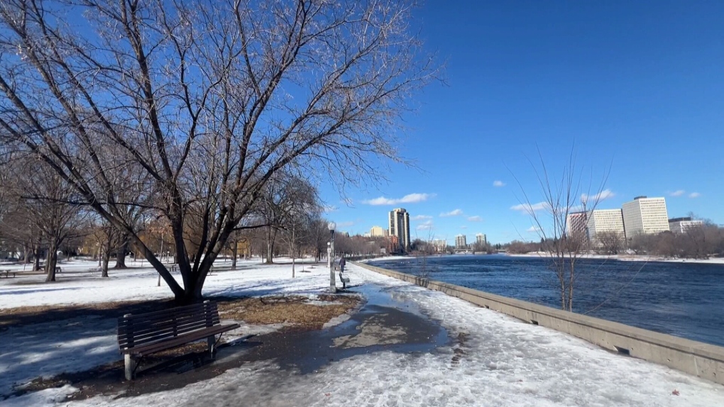
It’s unseasonably warm in Ottawa, but Environment Canada is warning about a potential flash freeze just days from now.
Environment Canada’s forecast called for a high of 16 C today, which would have broken the record for the warmest Feb. 27 in Ottawa history. The current record is 12.4 C, set back in 2000. So far, however, the temperature has only reached a high of 11.5 C at 2 p.m.
The temperature at 4 p.m. was 10.3 C.
Despite the unusually high temperatures, a flash freeze warning has been issued, with Environment Canada saying rapidly falling temperatures Wednesday night could cause wet surfaces to freeze.
“A dramatic change in temperatures is expected on Wednesday with the passage of a sharp cold front. Temperatures are expected to go from well above freezing to below freezing in just a matter of a few hours,” the weather agency said.
The forecast for Wednesday night includes a low of -13 C, after a daytime high of 14 C, a 27-degree swing.
Two days of warm weather before temperatures plummet
This could be the warmest February day in Ottawa history, as spring-like temperatures arrive in the national capital region for the final days of February.
“Typically, this is more like March than February so I’m a little surprised it has come so early,” David Phillips, Environment Canada senior climatologist, told CTV Morning Live on Tuesday. “My Gosh, our weather has got so weird, wild and wacky in recent years that nothing really surprises me.”
According to the social media account @YOW_Weather, a high of 16 C would be the warmest temperature ever recorded in Ottawa on a February day. The current high is 12.4 C, set on Feb. 27, 2000.
Wednesday’s high of 1 C would set a record for the warmest Feb. 28 in Ottawa history. The current record is 9.9 C, set back in 2018.
“You’re losing your reputation as one of the snowiest and one of the coldest national capitals in the world,” Phillips told Newstalk 580 CFRA’s Ottawa at Work with guest host Graham Richardson on Monday.
Phillips said the rapid swing in temperatures is unusual.
“It really is kind of bizarre, but this is what the weather has been this past winter particularly in the Ottawa area,” he said Tuesday.
Warm temperatures will return for the first weekend of March, with highs of 4 C on Friday, 7 C on Saturday and 9 C on Sunday.
Ottawa forecast
Mainly cloudy with a chance of showers this evening. Low 9 C.
Wednesday will see rain all day, with the risk of a thunderstorm. High 14 C.
Environment Canada says Ottawa will see Rain showers changing to flurries in the evening and ending after midnight, with a low of -13 C.
The outlook for Thursday calls for a mix of sun and cloud with a high of -7 C.
Friday will be sunny. High 4 C.
The normal temperatures for this time of year are a high of -2 C and a low of -11 C.
View original article here Source

Royale Velour Toilet Paper, 12 Equal 24 Rolls, 142 Bathroom Tissues per roll
$8.97 (as of April 19, 2024 09:47 GMT -05:00 - More infoProduct prices and availability are accurate as of the date/time indicated and are subject to change. Any price and availability information displayed on [relevant Amazon Site(s), as applicable] at the time of purchase will apply to the purchase of this product.)
Sahara Sailor Water Bottle, 32oz Motivational Sports Water Bottle with Time Marker - Times to Drink - Tritan, BPA Free, Wide Mouth Leakproof, Fast Flow Technology with Clean Brush by Gohippos (1 Bottle)
$14.99 (as of April 19, 2024 09:47 GMT -05:00 - More infoProduct prices and availability are accurate as of the date/time indicated and are subject to change. Any price and availability information displayed on [relevant Amazon Site(s), as applicable] at the time of purchase will apply to the purchase of this product.)
Gritin Resistance Bands, [Set of 5] Skin-Friendly Resistance Fitness Exercise Loop Bands with 5 Different Resistance Levels - Free Carrying Case Included - Ideal for Home, Gym, Yoga, Training
$14.99 (as of April 19, 2024 09:47 GMT -05:00 - More infoProduct prices and availability are accurate as of the date/time indicated and are subject to change. Any price and availability information displayed on [relevant Amazon Site(s), as applicable] at the time of purchase will apply to the purchase of this product.)
Owala FreeSip Insulated Stainless Steel Water Bottle with Straw for Sports and Travel, BPA-Free, 32oz, Dreamy Field
$38.69 (as of April 19, 2024 09:47 GMT -05:00 - More infoProduct prices and availability are accurate as of the date/time indicated and are subject to change. Any price and availability information displayed on [relevant Amazon Site(s), as applicable] at the time of purchase will apply to the purchase of this product.)
SOJOS Retro Oval Sunglasses for Women Men Trendy Sun Glasses Classic Shades UV400 Protection SJ1217
$21.99 (as of April 19, 2024 09:47 GMT -05:00 - More infoProduct prices and availability are accurate as of the date/time indicated and are subject to change. Any price and availability information displayed on [relevant Amazon Site(s), as applicable] at the time of purchase will apply to the purchase of this product.)
CAMBIVO Knee Brace Support(2 Pack), Knee Compression Sleeve for Running, Hiking, Basketball, Arthritis, ACL, Meniscus Tear, Knee Pain Relief and Injury Recovery
$27.99 (as of April 19, 2024 09:47 GMT -05:00 - More infoProduct prices and availability are accurate as of the date/time indicated and are subject to change. Any price and availability information displayed on [relevant Amazon Site(s), as applicable] at the time of purchase will apply to the purchase of this product.)
Jacked Factory Creatine Monohydrate Powder 425g - Creatine Supplement for Increased Muscle Mass*, Improved Strength, Power, & Performance** - 85 Servings, Unflavored
$29.99 (as of April 19, 2024 09:47 GMT -05:00 - More infoProduct prices and availability are accurate as of the date/time indicated and are subject to change. Any price and availability information displayed on [relevant Amazon Site(s), as applicable] at the time of purchase will apply to the purchase of this product.)
Utopia Bedding Bed Sheet Set - 4 Piece Queen Bedding - Soft Brushed Microfiber Fabric - Shrinkage & Fade Resistant - Easy Care (Queen, Grey)
$21.99 (as of April 19, 2024 09:47 GMT -05:00 - More infoProduct prices and availability are accurate as of the date/time indicated and are subject to change. Any price and availability information displayed on [relevant Amazon Site(s), as applicable] at the time of purchase will apply to the purchase of this product.)
Glad White Garbage Bags - Tall 45 Litres - ForceFlex, Drawstring, with Febreze Fresh Clean Scent, 50 Trash Bags, Made in Canada of Global Components
$11.65 (as of April 19, 2024 09:47 GMT -05:00 - More infoProduct prices and availability are accurate as of the date/time indicated and are subject to change. Any price and availability information displayed on [relevant Amazon Site(s), as applicable] at the time of purchase will apply to the purchase of this product.)