‘Heat dome’ to bring scorching temperatures to Ottawa, eastern Ontario starting today
A prolonged ‘heat dome’ will bring dangerously hot and humid conditions to Ottawa and eastern Ontario starting on Monday.
Environment Canada issued a heat warning for Ottawa late afternoon Sunday, with daytime highs through much of the week expected to be between 30 and 35 C. High humidity will make the temperature feel between 40 and 45 C.
There will be “little relief” in the evening hours, with overnight lows expected to be between 18 to 23 C and humidex values expected to make it feel between 26 and 30 C.
Temperatures will peak in Ottawa on Tuesday, with the forecast showing a high of 34 C. Conditions are expected to taper off before the weekend, with the forecast showing the heat dipping back down below 30 C on Friday.
“Extreme heat can affect everyone’s health,” Environment Canada’s says.
“The health risks are greater for older adults, infants and young children, pregnant people, people with physical and/or mental illnesses, and people with disabilities or mobility issues.”
Heat warnings have been issued across the province, stretching from Windsor to Ottawa, and northward to Moosonee. Warnings have also been issued in western and southern Quebec, including Gatineau, Montreal and Quebec City.
“It’s not a severe weather event that comes and then goes. This has got legs to it. It’s a heat dome,” Environment Canada’s senior climatologist David Phillips told CTV’s Jack Richardson on Sunday.
“From a health point of view, the first heat wave is often where we see hospitalizations.”
Phillips recommends drinking plenty of water and to stay away from caffeine and alcohol.
Environment Canada says to watch out for the effects of heat illness, including swelling, rash, cramps, fainting, heat exhaustion, heat stroke and the worsening of some health conditions.
“Call 911 or your local emergency number immediately if you or someone you are caring for has a high body temperature and are confused, has stopped sweating or becomes unconscious,” Environment Canada says.
BEAT THE HEAT
The City of Ottawa and National Capital Commission (NCC) beaches opened to the public last weekend. Lifeguards are on duty at city beaches until 7 p.m. daily.
Ottawa Public Health is not recommending swimming at Britannia Beach, due to high levels of E-coli detected in the water.
City splash pads are open from 9 a.m. to 9 p.m. daily. Atrium Park, Eugene Martineau Park and Joe Jamieson Park splash pads are currently closed for repairs.
Wading pools are only open on weekends.
A full list of places to cool off can be found on the City of Ottawa website.
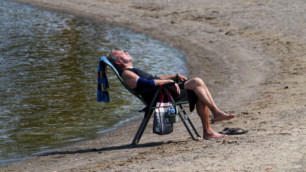 Duane relaxes on the banks of the Ottawa River in Ottawa on Tuesday, July 4, 2023. THE CANADIAN PRESS/Sean Kilpatrick
MONDAY FORECAST
Monday’s weather forecast shows cloudy skies with a 60 per cent chance of showers early this morning and a mix of sun and clouds. There is a risk of a thunderstorm in the morning.
High will be 31 C with a humidex of 39. UV index is nine or “very high.”
Tonight shows partly cloudy skies and a 30 per cent chance of showers this evening and overnight with a chance of thunderstorms. Low will be 21 C.
Tuesday calls for a mix of sun and clouds with a high of 34 C. There is a 30 per cent chance of showers early in the morning and late in the afternoon.
Wednesday shows a mix of sun and clouds with a 30 per cent chance of showers. High 32.
Similar conditions are expected on Thursday.
The heat event is expected to taper off by the weekend, though temperatures will remain in the mid-20’s.
View original article here Source

Utopia Bedding Bed Pillows for Sleeping Queen Size (Grey), Set of 2, Cooling Hotel Quality, Gusseted Pillow for Back,…
$39.99 (as of July 26, 2024 14:11 GMT -05:00 - More infoProduct prices and availability are accurate as of the date/time indicated and are subject to change. Any price and availability information displayed on [relevant Amazon Site(s), as applicable] at the time of purchase will apply to the purchase of this product.)
Amazon Basics 1/2-Inch Extra Thick Exercise Mat with Carrying Strap
$26.99 (as of July 26, 2024 14:11 GMT -05:00 - More infoProduct prices and availability are accurate as of the date/time indicated and are subject to change. Any price and availability information displayed on [relevant Amazon Site(s), as applicable] at the time of purchase will apply to the purchase of this product.)
Royale Velour Toilet Paper, 12 Equal 24 Rolls, 142 Bathroom Tissues per roll
$6.99 (as of July 26, 2024 14:11 GMT -05:00 - More infoProduct prices and availability are accurate as of the date/time indicated and are subject to change. Any price and availability information displayed on [relevant Amazon Site(s), as applicable] at the time of purchase will apply to the purchase of this product.)
Toys for Girls Boys, Colorful Doodle Board Drawing Tablet, Memo Board, Drawing Pads with Lanyard, Travel…
$22.99 (as of July 26, 2024 14:11 GMT -05:00 - More infoProduct prices and availability are accurate as of the date/time indicated and are subject to change. Any price and availability information displayed on [relevant Amazon Site(s), as applicable] at the time of purchase will apply to the purchase of this product.)
Amazon Basics Neoprene Hexagon Workout Dumbbell Hand Weight
$36.49 (as of July 26, 2024 14:11 GMT -05:00 - More infoProduct prices and availability are accurate as of the date/time indicated and are subject to change. Any price and availability information displayed on [relevant Amazon Site(s), as applicable] at the time of purchase will apply to the purchase of this product.)
Pure Protein Bars - Nutritious, Gluten Free protein bar, made with Whey protein blend - low sugar, protein snack.…
$10.47 (as of July 26, 2024 14:11 GMT -05:00 - More infoProduct prices and availability are accurate as of the date/time indicated and are subject to change. Any price and availability information displayed on [relevant Amazon Site(s), as applicable] at the time of purchase will apply to the purchase of this product.)
Gionlion 6000 Pcs Clay Beads for Bracelet Making, 24 Colors Flat Preppy Beads for Friendship Bracelet Kit,…
$16.99 (as of July 26, 2024 14:11 GMT -05:00 - More infoProduct prices and availability are accurate as of the date/time indicated and are subject to change. Any price and availability information displayed on [relevant Amazon Site(s), as applicable] at the time of purchase will apply to the purchase of this product.)
BOGI Microfiber Travel Sports Towel-Quick Dry Towel, Soft Lightweight Microfiber Camping Towel Absorbent Compact…
$18.70 (as of July 26, 2024 14:11 GMT -05:00 - More infoProduct prices and availability are accurate as of the date/time indicated and are subject to change. Any price and availability information displayed on [relevant Amazon Site(s), as applicable] at the time of purchase will apply to the purchase of this product.)
Botanic Hearth Rosemary Hair Oil with Biotin for Hair Care, Strengthening, Nourishing, and Volumizing Formula with…
$20.99 (as of July 26, 2024 14:11 GMT -05:00 - More infoProduct prices and availability are accurate as of the date/time indicated and are subject to change. Any price and availability information displayed on [relevant Amazon Site(s), as applicable] at the time of purchase will apply to the purchase of this product.)