Warm, windy weekend ahead
A low-pressure trough lingered over southern Alberta on Thursday, ushering in cool northwesterly winds gusting up to 40 km/h and scattered showers.
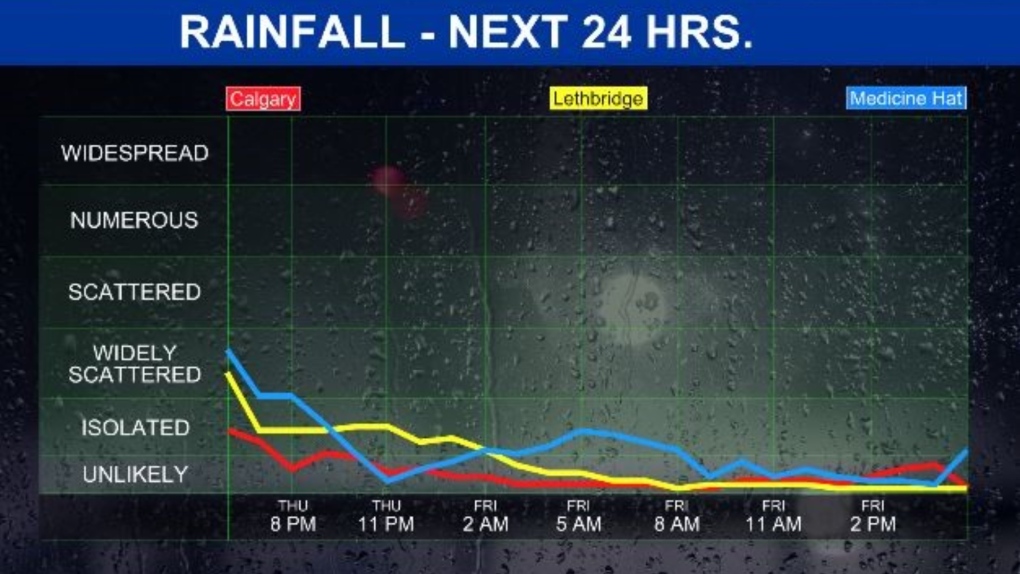
Rainfall amounts will be trace around Calgary, while the more intense storm activity was in north-central and eastern Alberta along the Saskatchewan border.
This system did trigger a severe thunderstorm warning for the region of Winnifred just southwest of Medicine Hat as the storm cells built in intensity and posed the risk of producing strong winds and nickel-sized hail, but this fast-moving low did not stick around for very long.
A risk of thunderstorms continues over the province in the evening, but will die off overnight as the upper low tracks into the eastern Prairie provinces.
Looking ahead to the last day of May, we will start with some calm northwest winds around 15 km/h, but they will pick up in the afternoon from the same direction at 20-40 km/h.
That will keep temperatures on the cooler side of normal (high of 19 C) with a forecast high of 16 C on tap for Friday.

Models are showing a 30 per cent chance of scattered showers over the city in the early afternoon, with gradual clearing conditions heading into Saturday.
The warming trend picks up momentum on Saturday with a high of 19 C in store, then a chinook setup takes over on Sunday with a high of 20 C and sunshine with some gusty westerly winds.

While the strong winds could pose a risk for wildfires, conditions will still be great to get outside and enjoy the first weekend of June!
View original article here Source

Mattel Games UNO Family Card Game, with 112 Cards in a Sturdy Storage Tin, Travel-Friendly, Makes a Great Game…
$7.97 (as of July 26, 2024 14:11 GMT -05:00 - More infoProduct prices and availability are accurate as of the date/time indicated and are subject to change. Any price and availability information displayed on [relevant Amazon Site(s), as applicable] at the time of purchase will apply to the purchase of this product.)
TYLENOL Extra Strength Cold eZ Tabs, Relieves Cold symptoms, Daytime, 40ct
$17.11 (as of July 26, 2024 14:11 GMT -05:00 - More infoProduct prices and availability are accurate as of the date/time indicated and are subject to change. Any price and availability information displayed on [relevant Amazon Site(s), as applicable] at the time of purchase will apply to the purchase of this product.)
Rael Miracle Invisible Spot Cover - Absorbing Cover, Skin Care, Facial Stickers, 2 Sizes (96 Count)
$24.99 (as of July 26, 2024 14:11 GMT -05:00 - More infoProduct prices and availability are accurate as of the date/time indicated and are subject to change. Any price and availability information displayed on [relevant Amazon Site(s), as applicable] at the time of purchase will apply to the purchase of this product.)
Jacked Factory Creatine Monohydrate Powder 425g - Creatine Supplement for Increased Muscle Mass*,…
$29.99 (as of July 26, 2024 14:11 GMT -05:00 - More infoProduct prices and availability are accurate as of the date/time indicated and are subject to change. Any price and availability information displayed on [relevant Amazon Site(s), as applicable] at the time of purchase will apply to the purchase of this product.)
Sunzel 10" / 8" / 5" / 3" Biker Shorts for Women with Pockets, High Waisted Yoga Workout Shorts
$20.99 (as of July 26, 2024 14:11 GMT -05:00 - More infoProduct prices and availability are accurate as of the date/time indicated and are subject to change. Any price and availability information displayed on [relevant Amazon Site(s), as applicable] at the time of purchase will apply to the purchase of this product.)
NATPAT Buzz Patch Stickers for Kids (60 Pack) - The Natural Patch - For Toddlers, Babies, Kids
$18.88 (as of July 26, 2024 14:11 GMT -05:00 - More infoProduct prices and availability are accurate as of the date/time indicated and are subject to change. Any price and availability information displayed on [relevant Amazon Site(s), as applicable] at the time of purchase will apply to the purchase of this product.)
Queen Size 4 Piece Sheet Set - Comfy Breathable & Cooling Sheets - Hotel Luxury Bed Sheets for Women & Men…
$29.99 (as of July 26, 2024 14:11 GMT -05:00 - More infoProduct prices and availability are accurate as of the date/time indicated and are subject to change. Any price and availability information displayed on [relevant Amazon Site(s), as applicable] at the time of purchase will apply to the purchase of this product.)
Botanic Hearth Rosemary Hair Oil with Biotin for Hair Care, Strengthening, Nourishing, and Volumizing Formula with…
$20.99 (as of July 26, 2024 14:11 GMT -05:00 - More infoProduct prices and availability are accurate as of the date/time indicated and are subject to change. Any price and availability information displayed on [relevant Amazon Site(s), as applicable] at the time of purchase will apply to the purchase of this product.)
Royale Velour Toilet Paper, 12 Equal 24 Rolls, 142 Bathroom Tissues per roll
$6.99 (as of July 26, 2024 14:11 GMT -05:00 - More infoProduct prices and availability are accurate as of the date/time indicated and are subject to change. Any price and availability information displayed on [relevant Amazon Site(s), as applicable] at the time of purchase will apply to the purchase of this product.)