Snowfall warnings issued south and west of Calgary ahead of multi-day snow event
It’s a classic southern Alberta springtime weather story – record heat one day and winter weather the next.
Four communities in Alberta set new maximum temperature records Tuesday, including Red Earth (northern Alberta), Slave Lake (north of Edmonton), Hendrickson Creek (north of Jasper), and Three Hills (northeast of Calgary).
The community of Masinasin in southern Alberta was the provincial hot spot Tuesday with a maximum temperature of 21.5 C.
On Wednesday, snowfall warnings were issued 48 kilometres west of Masinasin, extending west to the B.C. border and north along the foothills.
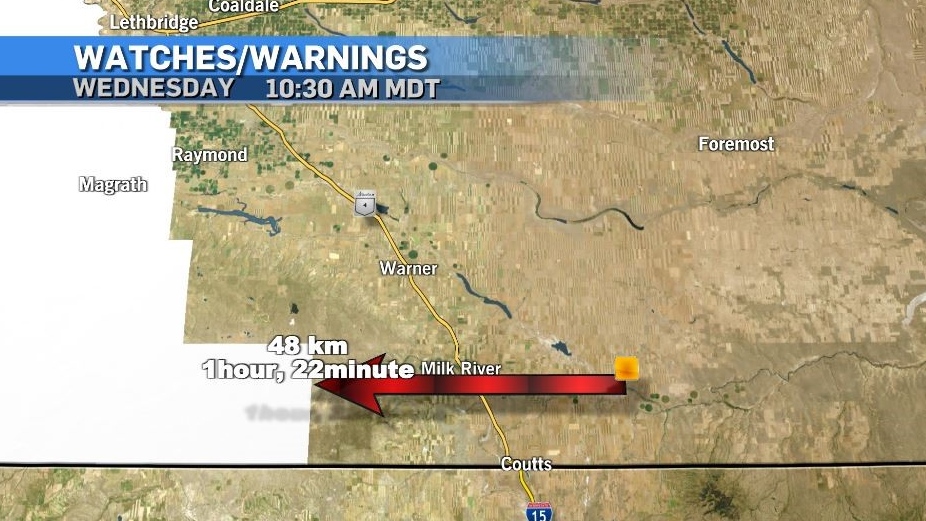 Hours after the community of Masinasin was the Alberta provincial hot spot on Tuesday (21.5 C), Environment and Climate Change Canada issued snowfall warnings 48 kilometres away.
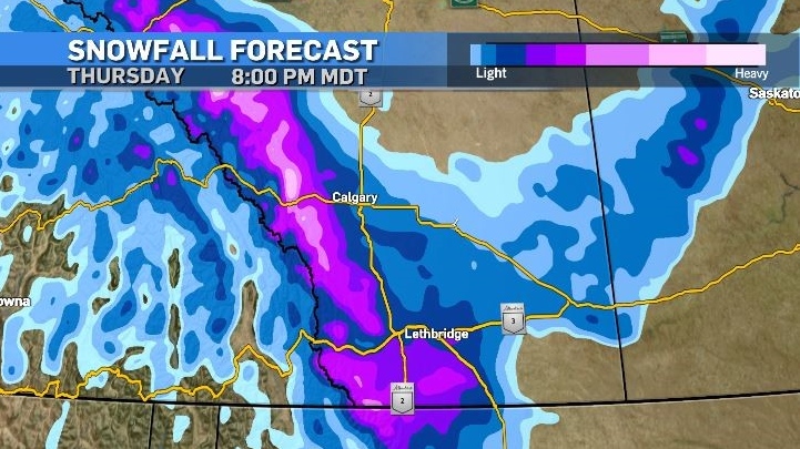
Environment and Climate Change Canada (ECCC) warned as much as 30 centimetres of snow could fall in some locations, but before the snow, rain and mixed precipitation are expected.
According to ECCC, Okotoks, High River and Claresholm could see between 10 and 20 centimetres of snow, and the agency warned, “Visibility may be suddenly reduced at times in heavy snow.”
Atmospheric profiles, surface temperatures, time of day and elevation will all be factors in determining how much snow falls and whether it accumulates.
Initially a frontal system will head toward the southern border of Alberta on Wednesday, with precipitation along the leading edge accompanied by strong north winds.
Overnight and early Thursday a second system will set up bringing the bulk of snow into the warned and surrounding regions.
The impact from this second system is highly dependant on where the system ends up – which is difficult to predict based on topography and corresponding environmental responses.
Upsloping flow is almost certain around the counter-clockwise rotation of the second low in southern Alberta, acting to amplify localized snowfall totals – however confidence in the track of this system is not high.
Daytime temperatures will remain below seasonal from Thursday until early next week, with a narrow gap between daily minimum and maximum (highs and low) temperatures.
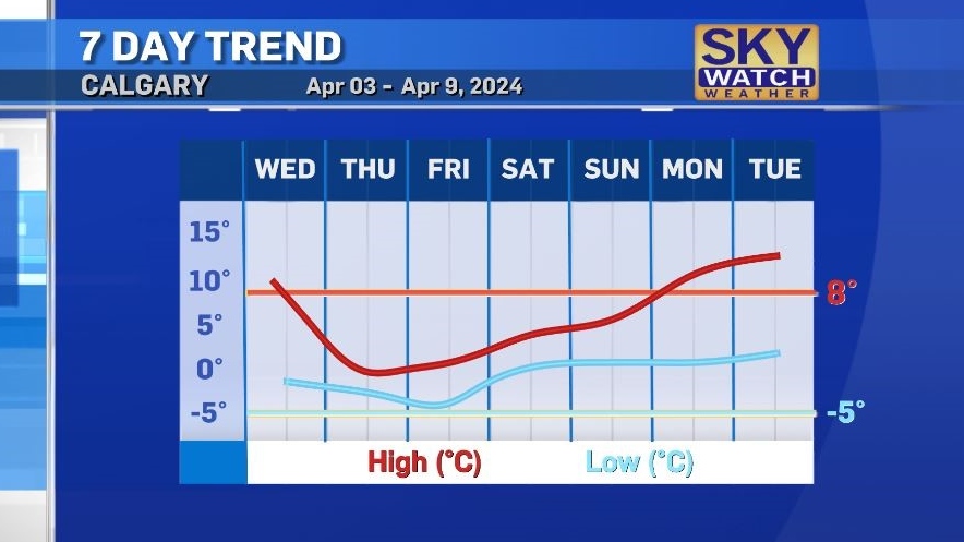
The trough that is situated along the southern west coast Wednesday will eventually become a closed low as it tracks east over the weekend and by Tuesday a ridge of high pressure will bring temperatures in Calgary back up to the low teens.
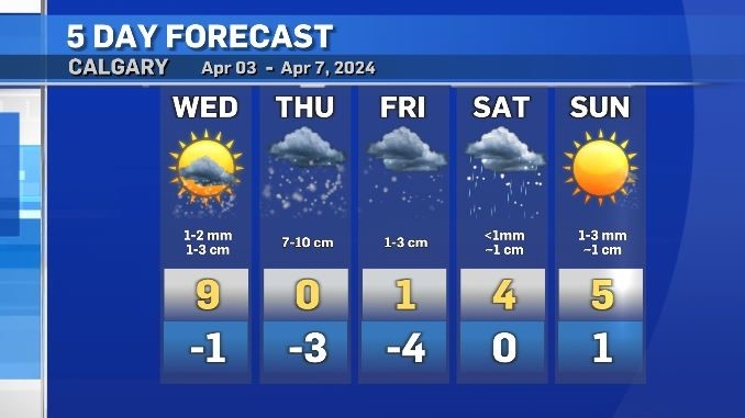
Snow should begin in Calgary by late evening Wednesday, with around 7 to 10 centimetres possible Thursday.
Surface temperatures will aid in road conditions, however areas that have pooling water, ice and/or snow will be vulnerable to icing up.
This is also true of bridge decks and open areas – depending on the duration of northerly flow over the aforementioned surfaced and surface saturation levels.
View original article here Source

Sunstar 888JC GUM Advanced Care Flossers, Fresh Mint, Vitamin E & Fluoride, 150 Count (packaging may vary)
$5.77 (as of April 19, 2024 09:47 GMT -05:00 - More infoProduct prices and availability are accurate as of the date/time indicated and are subject to change. Any price and availability information displayed on [relevant Amazon Site(s), as applicable] at the time of purchase will apply to the purchase of this product.)
Softsoap Antibacterial Liquid Hand Soap Refill - Clean Aloe Vera 1.47 Liters - Moisturizing Hand Wash, Savon a Main, Dermatologically Tested, for Soft Smooth Skin
$5.97 (as of April 19, 2024 09:47 GMT -05:00 - More infoProduct prices and availability are accurate as of the date/time indicated and are subject to change. Any price and availability information displayed on [relevant Amazon Site(s), as applicable] at the time of purchase will apply to the purchase of this product.)
Under Eye Mask - Reduce Dark Circles, Puffy Eyes, Undereye Bags, Wrinkles - Gel Under Eye Patches, Vegan Cruelty-Free Self Care by grace and stella (24 Pairs, Gold)
$25.95 (as of April 19, 2024 09:47 GMT -05:00 - More infoProduct prices and availability are accurate as of the date/time indicated and are subject to change. Any price and availability information displayed on [relevant Amazon Site(s), as applicable] at the time of purchase will apply to the purchase of this product.)
Apple iPhone 12, 64GB, Black - Fully Unlocked (Renewed)
$369.00 (as of April 19, 2024 09:47 GMT -05:00 - More infoProduct prices and availability are accurate as of the date/time indicated and are subject to change. Any price and availability information displayed on [relevant Amazon Site(s), as applicable] at the time of purchase will apply to the purchase of this product.)
CAMBIVO Knee Brace Support(2 Pack), Knee Compression Sleeve for Running, Hiking, Basketball, Arthritis, ACL, Meniscus Tear, Knee Pain Relief and Injury Recovery
$27.99 (as of April 19, 2024 09:47 GMT -05:00 - More infoProduct prices and availability are accurate as of the date/time indicated and are subject to change. Any price and availability information displayed on [relevant Amazon Site(s), as applicable] at the time of purchase will apply to the purchase of this product.)
Apple iPhone 13, 128GB, Midnight - Unlocked (Renewed)
$484.97 (as of April 19, 2024 09:47 GMT -05:00 - More infoProduct prices and availability are accurate as of the date/time indicated and are subject to change. Any price and availability information displayed on [relevant Amazon Site(s), as applicable] at the time of purchase will apply to the purchase of this product.)
BenSorts Women Men Pillow Sandals Adjustable Buckles Slides Thick Sole
$28.49 (as of April 19, 2024 09:47 GMT -05:00 - More infoProduct prices and availability are accurate as of the date/time indicated and are subject to change. Any price and availability information displayed on [relevant Amazon Site(s), as applicable] at the time of purchase will apply to the purchase of this product.)
Amazon Basics 20 Pack AA High-Performance Alkaline Batteries, 10-Year Shelf Life, Easy to Open Value Pack
$11.67 (as of April 19, 2024 09:47 GMT -05:00 - More infoProduct prices and availability are accurate as of the date/time indicated and are subject to change. Any price and availability information displayed on [relevant Amazon Site(s), as applicable] at the time of purchase will apply to the purchase of this product.)
Utopia Bedding Zippered Mattress Encasement Queen - 100% Waterproof and Bed Bug Proof Mattress Protector - Absorbent, Six-Sided Mattress Cover
$26.59 (as of April 19, 2024 09:47 GMT -05:00 - More infoProduct prices and availability are accurate as of the date/time indicated and are subject to change. Any price and availability information displayed on [relevant Amazon Site(s), as applicable] at the time of purchase will apply to the purchase of this product.)