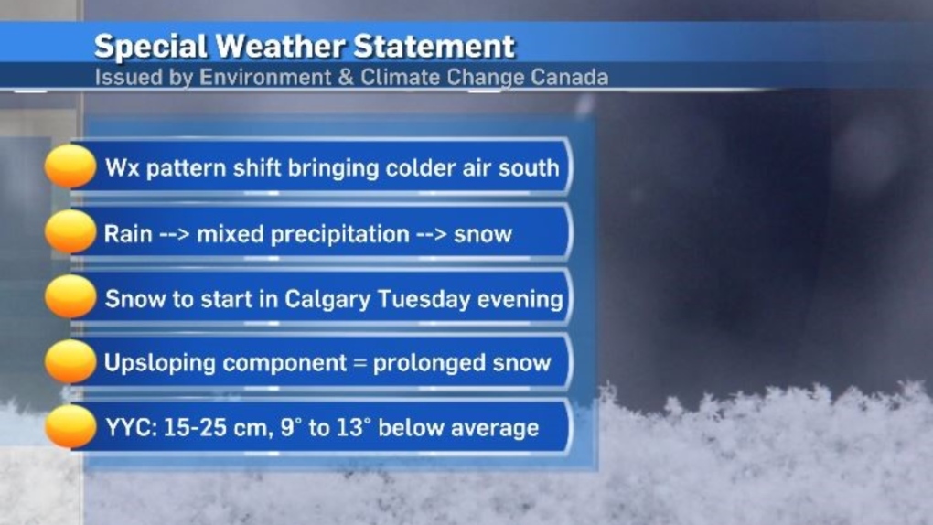
Special weather statement issued for Calgary, 15 to 25 cm of snow expected
Weather conditions in Calgary are expected to deteriorate rapidly starting Tuesday as a shift in the weather pattern brings Arctic air across the western Prairies.
This cold air will meet with a moist, Pacific air mass producing a classic spring scenario with heavy wet snow expected across the region.
Further complicating matters, the base of this trough (counter-clockwise rotation around a low pressure system) will sit along the southern edge of Alberta creating up sloping conditions.
Normally, weather moves from west to east across southern Alberta. During a scenario like the one currently developing in southern Alberta, systems can get anchored – or stall out – as they attempt to move in reverse (from east to west), and encounter the physical barrier of the Rocky Mountains.
Special weather statement issued for Calgary
A wide-spread special weather statement was issued by Environment and Climate Change Canada (ECCC) Tuesday that includes all of southern Alberta.
A corresponding snowfall warning has been issued north of that statement, and includes Red Deer.
The snowfall warning extends north of Ponoka, east of Stettler, west of Jasper and north of the Yellowhead highway along the Alberta-B.C. corridor.
In the snowfall warning, the national weather agency advises motorists to “prepare for quickly changing and deteriorating travel conditions.”
There is a good chance that snowfall warning will be expanded south as more certainty around the precipitation is firmed up.
According to the special weather statement, “Over 48 hours, snowfall totals of 15 to 25 cm are expected for parts of southern Alberta. Higher amounts are possible over the eastern slopes of the Rocky Mountains.”
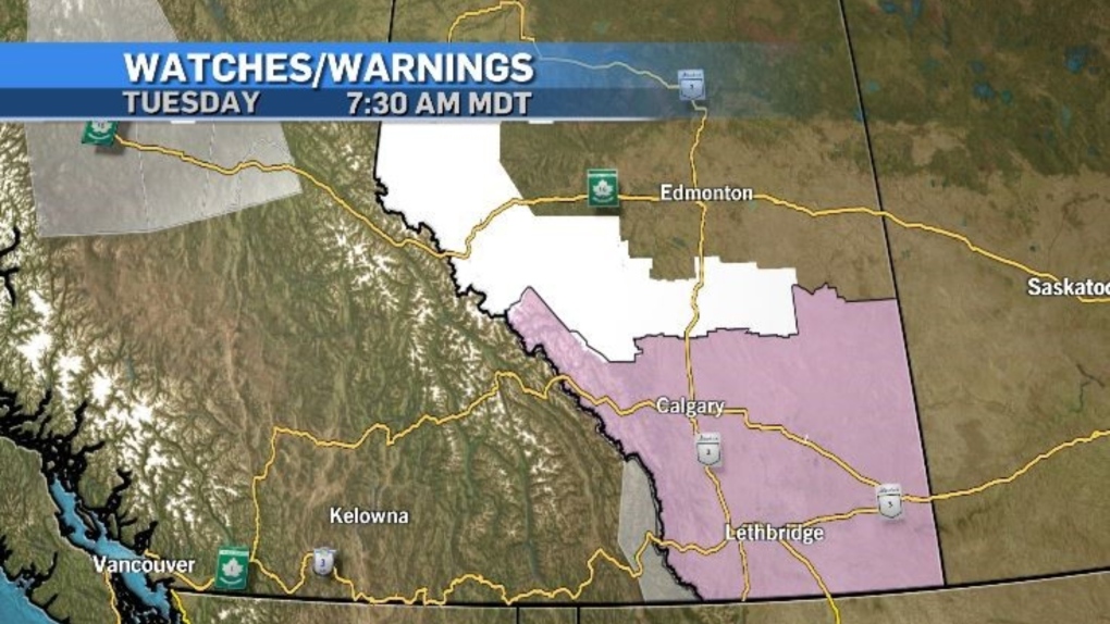 Weather advisories from ECCC on Tuesday, March 19, 2024 include a snowfall warning (white), a special weather statement (pink) and air quality advisories (gray). Unseasonably warm conditions over the weekend have left surface temperatures warm, meaning the snow from the start of this weather event will melt rather than accumulate on roadways and sidewalks. But as daytime highs sink below freezing and settle in a range colder than the average overnight low of -8 C, that snow will start to accumulate.
 The total snowfall accumulation in Calgary will likely vary across the city, but the general range is expected to fall between 12 and 20 centimetres.
Visibility may be compromised in some communities as the snow is initially falling – due to a stronger wind while the frontal system is entering the region.
Rates of precipitation will dictate whether snowfall warnings are expanded and extended by ECCC. Snowfall warnings are issued in Alberta when 10 centimetres (or more) of snow falls over a period of 12-hours or less.
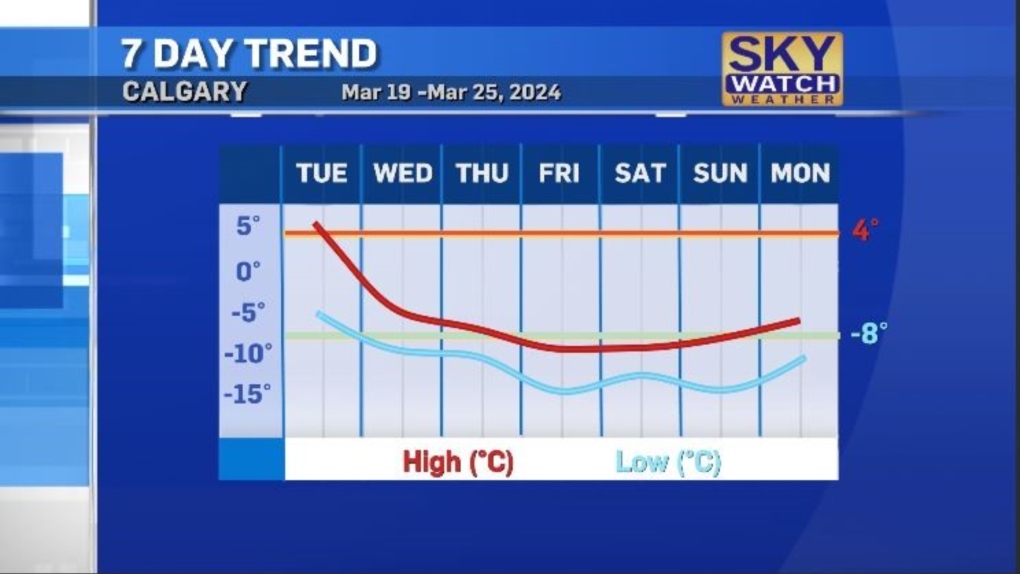
The bulk of precipitation is Calgary is expected on Wednesday and Thursday, however cloud cover and scattered flurries are likely until Saturday.
For the latest weather advisories from ECCC click here.
View original article here Source

Utopia Bedding Bed Pillows for Sleeping Queen Size (Grey), Set of 2, Cooling Hotel Quality, Gusseted Pillow for Back, Stomach or Side Sleepers
$39.99 (as of April 13, 2024 08:31 GMT -05:00 - More infoProduct prices and availability are accurate as of the date/time indicated and are subject to change. Any price and availability information displayed on [relevant Amazon Site(s), as applicable] at the time of purchase will apply to the purchase of this product.)
travel inspira Luggage Scale, Portable Digital Hanging Baggage Scale for Travel, Suitcase Weight Scale with Rubber Paint, 110 Pounds, Battery Included - Red
$11.62 (as of April 13, 2024 08:31 GMT -05:00 - More infoProduct prices and availability are accurate as of the date/time indicated and are subject to change. Any price and availability information displayed on [relevant Amazon Site(s), as applicable] at the time of purchase will apply to the purchase of this product.)
Zulay Powerful Milk Frother Handheld Foam Maker for Lattes - Whisk Drink Mixer for Coffee, Mini Foamer for Cappuccino, Frappe, Matcha, Hot Chocolate by Milk Boss (Black)
$13.39 (as of April 13, 2024 08:31 GMT -05:00 - More infoProduct prices and availability are accurate as of the date/time indicated and are subject to change. Any price and availability information displayed on [relevant Amazon Site(s), as applicable] at the time of purchase will apply to the purchase of this product.)
Vtopmart Cereal Storage Container Set, BPA Free Plastic Airtight Food Storage Containers 135.2 fl oz for Cereal, Snacks and Sugar, 4 Piece Set Cereal Dispensers with 24 Chalkboard Labels, Black
$61.05 (as of April 13, 2024 08:31 GMT -05:00 - More infoProduct prices and availability are accurate as of the date/time indicated and are subject to change. Any price and availability information displayed on [relevant Amazon Site(s), as applicable] at the time of purchase will apply to the purchase of this product.)
Apple iPhone 13, 128GB, Midnight - Unlocked (Renewed)
$495.00 (as of April 13, 2024 08:31 GMT -05:00 - More infoProduct prices and availability are accurate as of the date/time indicated and are subject to change. Any price and availability information displayed on [relevant Amazon Site(s), as applicable] at the time of purchase will apply to the purchase of this product.)
Glad White Garbage Bags - Tall 45 Litres - ForceFlex, Drawstring, with Febreze Fresh Clean Scent, 50 Trash Bags, Made in Canada of Global Components
$11.88 (as of April 13, 2024 08:31 GMT -05:00 - More infoProduct prices and availability are accurate as of the date/time indicated and are subject to change. Any price and availability information displayed on [relevant Amazon Site(s), as applicable] at the time of purchase will apply to the purchase of this product.)
2019 Apple iPad (10.2-Inch, Wi-Fi, 32GB) - Space Gray (Renewed)
$247.00 (as of April 13, 2024 08:31 GMT -05:00 - More infoProduct prices and availability are accurate as of the date/time indicated and are subject to change. Any price and availability information displayed on [relevant Amazon Site(s), as applicable] at the time of purchase will apply to the purchase of this product.)
Rael Miracle Invisible Spot Cover - Absorbing Cover, Skin Care, Facial Stickers, 2 Sizes (96 Count)
$24.99 (as of April 13, 2024 08:31 GMT -05:00 - More infoProduct prices and availability are accurate as of the date/time indicated and are subject to change. Any price and availability information displayed on [relevant Amazon Site(s), as applicable] at the time of purchase will apply to the purchase of this product.)
Tetley Super Herbal Boost Tea: Peach, Ginger & Dandelions with Vitamin B6 - 20 Tea Bags, 40 Grams, Naturally Caffeine Free
$2.47 (as of April 13, 2024 08:31 GMT -05:00 - More infoProduct prices and availability are accurate as of the date/time indicated and are subject to change. Any price and availability information displayed on [relevant Amazon Site(s), as applicable] at the time of purchase will apply to the purchase of this product.)