Extreme cold warnings expanded across country; snowfall warnings remain for southern Alberta
A persistent weather pattern is funnelling arctic air across the Prairies, which forced Environment and Climate Change Canada (ECCC) to issue extreme cold warnings late Thursday.
The national weather agency expanded those warnings Friday night, and as of 7:30 p.m., including the Yukon, Northwest Territories, Alberta, Saskatchewan, Manitoba and Ontario.
Wind chill values under the warned areas are likely to drop to at least -40 at times, especially early in the morning Saturday.
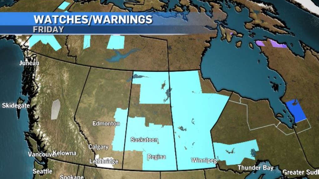
At the same time that colder air is meandering south, a slow-moving, moisture-laden system is edging north into southern British Columbia.
That Pacific air mass is going to track east toward the southern Rockies, where it will meet up with the western edge of the polar air mass and deliver up to 15 centimetres of snow for the southwest corridor of Alberta.
Snowfall warnings issued from ECCC note visibility is likely to be compromised in this area and road conditions will deteriorate when the two systems collide.
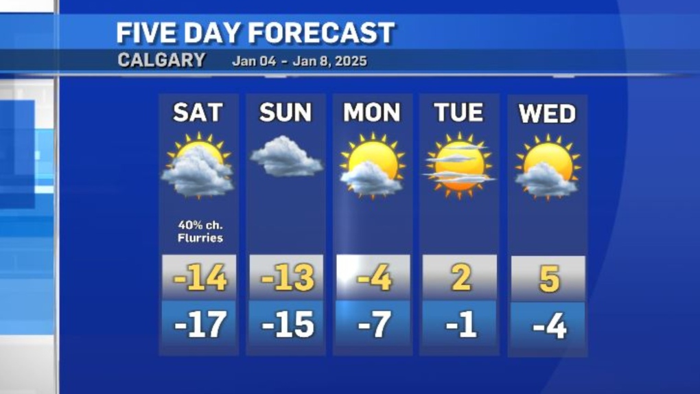
An incoming ridge of high pressure heading up the U.S. west coast will finally dislodge this stagnant pattern early next week, and daytime highs in southern Alberta will rise quickly.
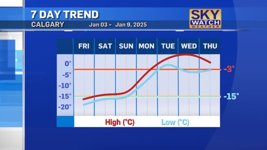
By Wednesday, it could be as warm as 5 C in Calgary, or eight degrees warmer than the average high of -3 C, a sharp change from Friday’s high of -15 C, which equals the average overnight low value this time of year.
View original article here Source

WaterWipes Plastic-Free Original Baby Wipes, 99.9% Water Based Wipes, Unscented & Hypoallergenic for Sensitive Skin, 720 Count (12 packs), Packaging May Vary
$57.98 (as of February 18, 2025 18:45 GMT -06:00 - More infoProduct prices and availability are accurate as of the date/time indicated and are subject to change. Any price and availability information displayed on [relevant Amazon Site(s), as applicable] at the time of purchase will apply to the purchase of this product.)
ROCKBROS Men's Balaclava Windproof Ski Mask Cold Weather Balaclava Mask Winter Thermal Hood for Skiing Cycling Helmet
$25.99 (as of February 18, 2025 18:45 GMT -06:00 - More infoProduct prices and availability are accurate as of the date/time indicated and are subject to change. Any price and availability information displayed on [relevant Amazon Site(s), as applicable] at the time of purchase will apply to the purchase of this product.)
Amazon.ca Gift Card Balance Reload
$25.00 (as of February 18, 2025 18:45 GMT -06:00 - More infoProduct prices and availability are accurate as of the date/time indicated and are subject to change. Any price and availability information displayed on [relevant Amazon Site(s), as applicable] at the time of purchase will apply to the purchase of this product.)
Pure Protein Bars - Nutritious, Gluten Free bar, made with Whey protein blend - low sugar, protein snack. Deliciously satisfying. Cookies and Cream (Pack of 6)
$12.49 (as of February 18, 2025 18:45 GMT -06:00 - More infoProduct prices and availability are accurate as of the date/time indicated and are subject to change. Any price and availability information displayed on [relevant Amazon Site(s), as applicable] at the time of purchase will apply to the purchase of this product.)
Organika Canadian-Made Enhanced Collagen Powder - for Healthy Hair, Skin, Nails, and Joints. Hydrolyzed Protein Peptides for Better Absorption- Grass-Fed, Non-GMO- Unflavoured- 500g
$44.49 (as of February 18, 2025 18:45 GMT -06:00 - More infoProduct prices and availability are accurate as of the date/time indicated and are subject to change. Any price and availability information displayed on [relevant Amazon Site(s), as applicable] at the time of purchase will apply to the purchase of this product.)
Huggies Diapers Size 3- Little Snugglers Disposable Baby Diapers, 156ct, One Month Supply
$42.49 (as of February 18, 2025 18:45 GMT -06:00 - More infoProduct prices and availability are accurate as of the date/time indicated and are subject to change. Any price and availability information displayed on [relevant Amazon Site(s), as applicable] at the time of purchase will apply to the purchase of this product.)
Amazon.ca eGift Card (Instant Email or Text Delivery)
$40.00 (as of February 18, 2025 18:45 GMT -06:00 - More infoProduct prices and availability are accurate as of the date/time indicated and are subject to change. Any price and availability information displayed on [relevant Amazon Site(s), as applicable] at the time of purchase will apply to the purchase of this product.)
Sudocrem - Diaper Rash Cream for Baby, Soothes, Heals, and Protects, Relief and Treatment of Diaper Rash, Zinc Oxide Cream - 250g
$14.97 (as of February 18, 2025 18:45 GMT -06:00 - More infoProduct prices and availability are accurate as of the date/time indicated and are subject to change. Any price and availability information displayed on [relevant Amazon Site(s), as applicable] at the time of purchase will apply to the purchase of this product.)
Iron Flame
$28.82 (as of February 18, 2025 18:45 GMT -06:00 - More infoProduct prices and availability are accurate as of the date/time indicated and are subject to change. Any price and availability information displayed on [relevant Amazon Site(s), as applicable] at the time of purchase will apply to the purchase of this product.)